Garmin zūmo XT: The Complete Nav
(Ed. note – read Mark Barnes’ review of Touratech’s locking mount for this and other navigation devices.)
The current capstone of Garmin’s line of moto-friendly GPS navigation units, the zūmo XT, recently debuted. I’ve often heard grumblings about previous zūmo models, including difficulty viewing the screen under certain daylight conditions and frustration when attempting to use a gloved finger to address the touchscreen. For some, these are minor nits being picked; for others these are dealbreakers. Happily, Garmin has not only addressed these issues, but managed to creatively pack an impressive host of innovative features into the XT.

The XT’s 5.5-inch screen is easily readable, even with sunglasses, in all light conditions I’ve encountered to date, including brightest central Florida summer sun. Even the smallest roads and trails are visible down to the 0.8 miles scale. I find no need for a sunshade. The touchscreen responds reliably and positively to a light but firm touch or tap by a gloved or bare forefinger; any glove appears to work well. Touch accuracy with a glove is acceptable. Panning can be done with a gloved finger on the screen.
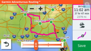
Innovative features include hands-free calling and SOS requests from anywhere to InReach® satellites (requires purchase of InReach unit). Four levels of Adventurous Routing algorithms replace the previous Curvy Roads selection, and of course the XT includes maps with lifetime updates which happen automatically over WiFi. Garmin also includes a topographic map and free access to BirdsEye images (think Google Earth) that can be downloaded as an overlay on a map with or without a current route running. Switchable map overlay choices can be easily accessed on the fly.
 A track recorder app is more intuitive and easy to access than on previous units. Selectable settings enable riders to be forewarned before speed limit drops, school zones, upcoming sharper curves and other special hazards. Alerts can be displayed both onscreen and audibly. A fuel minder app, once set for the specifics of your vehicle, will not only remind you when you reach a low fuel threshold, but will automatically ask you if you want to reset the fuel counter when it detects you have stopped at a gas station. After several hours of continual riding, the XT will automatically offer up a ‘Need A Break?’ screen showing the closest food, fuel and rest stops, with one finger-tap needed to reroute for tank or tummy.
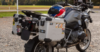
An internal battery is good for a claimed 3-6 hours, and a specific RAM-based 12-volt powered motorcycle mount is included; my bumpy off-pavement experiences have so far revealed no weaknesses in the mounting system. As a Garmin product, map, waypoint and route management is handled both internally and with BaseCamp. Described as rain-resistant, my XT has survived a number of Florida summer deluges without issues.
 Free current weather conditions, forecasts, driving conditions and radar, as well as current traffic information, including access to actual traffic cameras, are powered to the XT through the Garmin Drive smartphone app. The music player is straightforward and enables access to your smartphone’s music library or MP3 files stored on the XT. The user can add a microSD card up to 256 GB (the manual says 64 GB, but this appears to be an error) to store data, music, maps, tracks and more.
The phone app is also simple and effective; I use a Cardo PackTalk Bold helmet communicator, and the ability to see an incoming caller’s ID, as well as hear it and answer with a finger-tap is easy. Phone conversations, once a user gets all the settings in the unit to ones’ liking, are clear and sufficiently loud for most conditions. Tracks and routes can be managed with the Garmin Explore app.
Incident Detection is another new feature. In the event the XT detects an incident (crash, drop, violent movement followed by inactivity), the InReach function can summon help worldwide. A alert text can also be sent to parties selected by the rider. The XT will display text messages and alerts from the user’s smartphone and even read to the user audibly. A clever Round Trip app makes it easier to find engaging loops with a selected degree of Adventure.
 The XT enhances the process of finding interesting riding destinations with purpose with resources such as Foursquare and Trip Advisor. Other Where To resources include Ultimate Public Campgrounds, National Parks, Motorcycle Locations (retailers and repair), History Channel destinations (museums, parks, etc.), nearby fuel and prices and other normal criteria (food, fuel, lodging, etc.). Finding a destination and reason to ride has never been easier; choosing how you wish to shape the route is icing on the cake.
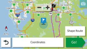
Route Shaping is another innovative feature of the XT, an improvement over the practice of adding a Via Point to redirect an existing route to travel to specific locations, roads or regions as a part of the route. Now, by simply touching the screen, usually zoomed out to “Full Route View,” the rider simply touches the map in the general area desired, or by zooming in, a specific location or destination, and the XT automatically recalculates the route to find the roads best suited to your request and current route profile. If you don’t like the result, simply touch somewhere else and you have the option to either add additional touch or to delete the previous touch and try again. Multiple “Shaping Points” can be added to shape a route to your liking.
 The zūmo XT is an Android-based system and uses a variety of apps in the same way as a smartphone or tablet. Available apps include ones for the Owner’s Manual, Trip Planner, TracBack, Weather and Traffic, live Traffic Cameras, Red Light and Speed camera, service history and more to give riders access to copious amount of information and functionality. A setting enables a user to tap an icon and take an instant screenshot of the GPS; the images can then be transferred to another device.
With about a month and a thousand miles or so of XT experience, I find this to be the most advanced unit I’ve used. My complaints are minor: Recalculating a route, in order to change the route’s characteristics (Fastest, Shortest, Adventurous levels 1-4) on the fly is impractical and usually requires stopping to manipulate the unit with a number of inputs. Route Shaping on the fly, however, is easy and often has a similar effect.
The sheer amount of information and data can lead a rider to become overly-fixated on the unit to the detriment of critical current situational awareness. Many functions can be accomplished on the fly with a single quick glance and finger tap, but the more complex call for the responsible rider to pull over and stop in the shade to address the XT.
 Two minor misses: The XT uses Garmin’s ANT technology to communicate through the InReach unit, but does not support ANT Tire Pressure Monitoring systems or Ambient Air Temperature sensors. The temperature displayed emanates from the weather app, and is regional. I would like to know the actual air temperature where I am at the moment. Perhaps future upgrades will address these matters.
With the increasing complexity of electronic devices and farkles, technical issues can arise. A Google search for zūmo XT forums can be very helpful. Some issues include difficulties using Bluetooth and mesh network helmet headsets. My helmet sports a Cardo PackTalk Bold, and it works flawlessly with the XT. Forum users offer a number of technical tips and workarounds.
With such a rich palette of features, it behooves the new zūmo XT owner to hunker down in the easy chair for a few hours to get familiar with the many features, functions, settings, views and apps in the zūmo XT; learning the unit while attempting to manage the risks of riding is not recommended.
Available from a wide variety of retailers for $499, I find the zūmo XT to be a worthy successor to my previous unit, a 276Cx. It’s not perfect, but it’s gaining on it.
NOTE: Mac users may find it necessary to learn a specific routine to get the XT to communicate with BaseCamp; not all Garmin reps are familiar with this. Frustrated Mac fans may write me if they wish.